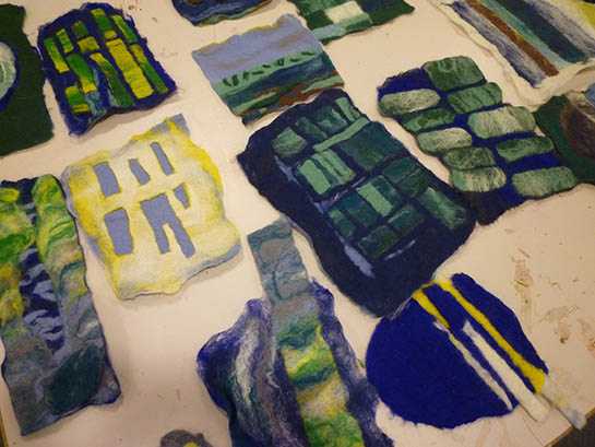
“All perceiving is also thinking, all reasoning is also intuition, all observation is also invention.” This quote of Rudolf Arnheim was the starting point of the 4 hour mapping workshop for graduate students [1]. Two landscape types, graphite, paper, cups and silverwork were the means to explore mapping as a tool in landscape architecture.
The two landscape types were taken from J.B. Jackson’s seminal book ‘The Vernacular Landscape’, where he described the political and the vernacular landscape. By the political landscape he meant those spaces and structures designed to impose or preserve an unity and order on the land, or in keeping with a long-range, large-scale plan (well-defined territories, public spaces, large-scale production landscapes). The vernacular landscape is one where evidences of a political organization of space are largely or entirely absent (absence of defined, permanent spaces).
After a lively discussion the structures of the political landscape were set up in wet graphite following a set of rules. Step by step this landscape evolved according to the master plan. After a while, the initial setup was overlaid with dusty graphite using natural forces such as water and ‘wind’ (since it was in a classroom we had to simulate by blowing ;-)). The result was a landscape of unexpected beauty showing human interventions confronted with natural patterns.
The vernacular landscape was created by a succession of spontaneous actions. At the moment we began, patterns of graphite started to evolve responding to the field conditions set by the table and the tools used. Some structures stayed and became part of an incremental process, others disappeared. Sometimes nature took over and added another layer. In the end the landscape was like a palimpsest presenting the result of the dialogue between processes of inhabitation and natural forces through time.

While reflecting on the mapping exercise we wondered how we could use this in the practice of landscape architecture. What could we learn from this? In both cases the initial intervention remained and became a modus operandi for the development of landscape by natural and sociocultural processes. This intervention can be architectural in nature, or more practical, but always precise and geared to achieve certain goals in space and time. Close reading of real-life landscapes all over the world reveals the unexpected beauty and logic of spatial organisation in this types of landscape. Examples can be found on e.g. http://geopathology.posterous.com/, such as:

This landscape in the delta of the Vjoses River, Albania (north to the right), where an occupation grid is superimposed on the fertile river landscape. This grid establishes a modular system and alternating pattern of parcellation, drainage canals and roads, which can be extended seaward, to obtain new land created by processes of accretion (in Dutch: aanwas).

Or this landscape in the North-East of Iran (north to the left), where the pattern of agricultural fields is closely related to the structure of an alluvial fan, taking advantage of the geological processes of erosion and sedimentation. Interventions are geared to optimize use of water and fertile sediment.
To conclude: by mapping physical, biological and cultural aspects we can understand the organization of space, how landscapes were created and how they change. It reveals certain ways of defining and handling space and time. In that respect “mappings are neither depictions nor representations but mental constructs, ideas that enable and effect change. It is a tool to explore and create new realities. Mapping is already a project in the making”, as James Corner puts it.
[1] The graduate students who created the maps: Anna Ioannidou, Nikolaos Margaritis, Lisanne van Niekerk and Mariska van Rijswijk; the workshop was led by John Lonsdale and Steffen Nijhuis.